
Poster 6
Tytuł badań:
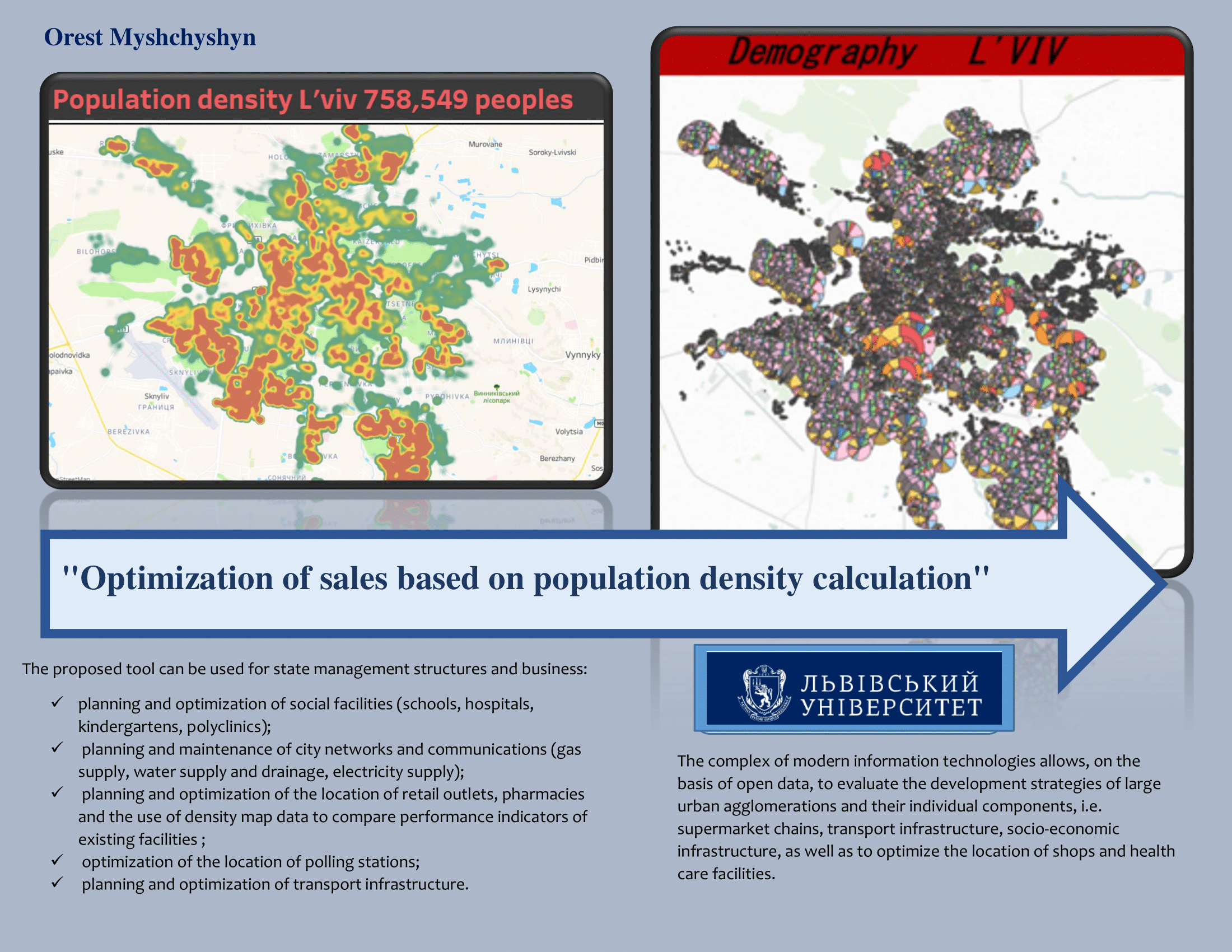
Optimization of sales based on population density calculation
Autor:
Orest Myshchyshyn
The population density of the entire settlement is one of the key characteristics of socio-economic processes taking place in society, which allows effective and well-considered management decisions to be made. However, for accurate research, we need data on population density in smaller areas, such as 100x100 meters. Only one or more buildings can be placed in this zone. For such an accurate calculation of population density, a separate house and its main characteristics should be taken as a basis: floor space, number of entrances, apartments and, accordingly, residents. Therefore, a map of objects was created according to their geographical coordinates of longitude and latitude. Each point represents one house. Such a map for the city of Lviv can be viewed at the link.
https://public.tableau.com/app/profile/orestmyshchyshyn/viz/Density_Lviv/Dashboard1
Using the capabilities of the Tableau program based on the population density map of the city of Lviv, a tool was also created that allows you to calculate the number of residents in the vicinity of a specific point, the population density in a specific area, and display the types of buildings and their addresses.
The proposed tool can be used in state and business management structures:
- planning and optimization of social facilities (schools, hospitals, kindergartens, polyclinics);
- design and maintenance of city networks and communications (gas supply, water supply and drainage, electricity supply);
- planning and optimization of the placement of retail outlets, pharmacies and the use of density map data to compare the efficiency indicators of existing facilities ;
- optimization of the location of polling stations;
- planning and optimization of transport infrastructure.
For large cities, OpenStreetMap electronic maps, which were used to calculate population density, are almost completely filled with objects, in addition, other sources of information about buildings and residents of settlements (databases, satellite images of the earth's surface) are freely available. The situation with small cities is completely different. To create density maps of small settlements, you must first map features to OpenStreetMap maps.
With the help of the Tableau program and the determined population density, a map of Lviv's supermarket coverage was also created. Such a map can be viewed and used at the address.
https://public.tableau.com/profile/orestmyshchyshyn#!/vizhome/GavrRox/Dashboard1
This map shows supermarket chains. For all retail outlets of the supermarket chain within a radius of 300 meters from each outlet, the total population and age structure (demography) were estimated, and the costs of purchasing goods for different age categories were calculated. On the basis of demographic data, an analysis of the purchasing power of different segments of the population of Lviv was carried out. On the basis of the given data, an analysis of the coverage of the city by supermarket chains of the following retail chains: ATB, Arsen, Silpo, Blyzen’ko was carried out.
In addition, population density maps were created for Ternopil, Ryashev and Lodz.
The complex of modern information technologies allows, on the basis of open data, to evaluate the development strategies of large urban agglomerations and their individual components, i.e. supermarket chains, transport infrastructure, socio-economic infrastructure, as well as to optimize the location of shops and health care facilities.
Associate Professor, Department of Digital Economics and Business Analytics Lviv National University of Ivan Franko

Orest Myshchyshyn
Doctor of Physical and Mathematical Sciences (Lviv, Ukraine)
orest_m_j@ukr.net
+380677201736